What are my GPS coordinates?
GPS coordinates Map
More Information
What is my latitude and longitude?
Find your GPS coordinates (latitude and longitude) based on your current device location, along with your full address and more.
What are GPS coordinates? GPS coordinates are simply numbers that represent your exact position in space with respect to Earth when looking along fixed geographic boundaries or directions.
GPS stands for Global Positioning System, which is a network of satellites that orbit the Earth and provide location and time information to any device that can receive their signals. GPS coordinates are numerical values that represent the exact position of a point on the Earth’s surface in terms of latitude and longitude.
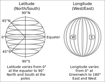
Latitude is the angle between the equator and a point on the Earth’s surface, measured in degrees north or south. Longitude is the angle between the prime meridian and a point on the Earth’s surface, measured in degrees east or west. Together, latitude and longitude form a unique pair of numbers that can pinpoint any location on the globe.
You can find out your GPS coordinates by using our website. Our website uses your device’s location services to determine your current location and show you your GPS coordinates (latitude and longitude) in decimal degrees format. You can also see a map of your location and zoom in or out to explore the surrounding area. You can also share your GPS coordinates with your friends and family via email, social media, or messaging apps.
Our website is fast, and easy to use. You don’t need to download any app or sign up for any account. You just need to allow our website to access your location and we will do the rest.
About Geographic coordinate system

A geographic coordinate system (GCS) is a spherical or geodetic coordinate system for measuring and communicating positions directly on Earth as latitude and longitude. It is the simplest, oldest, and most widely used type of the various spatial reference systems that are in use, and forms the basis for most others. Although latitude and longitude form a coordinate tuple like a cartesian coordinate system, geographic coordinate systems are not cartesian because the measurements are angles and are not on a planar surface.